Today is the first major rain of the fall season here in Vancouver, WA. While it is wet and blustery outside, I am inside thinking about and relishing my "day trip of the year" which took place last Wednesday at this time.
There is something restorative to me to be on the water. (I'm sure I wouldn't feel that way in the middle of a full blown storm at sea.) But calm waters sooth my soul. Even a bit turbulent waters stir something deep inside of me.
Since the Columbia River is central to life here in the Pacific Northwest I am eager to learn and experience a little more about it.
Columbia River
From Wikipedia, the free encyclopedia
| Columbia River | |
|
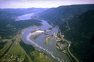
Bonneville Dam, in the Columbia River Gorge
| |
| Name origin: Captain Robert Gray's ship, Columbia Rediviva | |
| Nickname: Big River, the River of the West, River Oregon[1] | |
| Wikimedia Commons: Columbia River | |
The Columbia River is the largest river in the Pacific Northwest region of North America.[9] The river rises in the Rocky Mountains of British Columbia, Canada. It flows northwest and then south into the US state of Washington, then turns west to form most of the border between Washington and the state of Oregon before emptying into the Pacific Ocean. The river is 1,243 miles (2,000 km) long, and its largest tributary is the Snake River. Its drainage basin is roughly the size of France and extends into seven U.S. states and a Canadian province.
By volume, the Columbia is the fourth-largest river in the United States; it has the greatest flow of any North American river draining into the Pacific. The river's heavy flow and its relatively steep gradient gives it tremendous potential for the generation of electricity. The 14 hydroelectric dams on the Columbia's main stem and many more on its tributaries produce more hydroelectric power than those of any other North American river.
The Columbia and its tributaries have been central to the region's culture and economy for thousands of years. They have been used for transportation since ancient times, linking the many cultural groups of the region. The river system hosts many species of anadromous fish, which migrate between freshwater habitats and the saline Pacific Ocean. These fish—especially the salmon species—provided the core subsistence for natives; in past centuries, traders from across western North America traveled to the Columbia to trade for fish.
The 100 mile, 8 hour cruise route on the Portland Spirit.....
Observe that the Columbia River is the border between
Oregon and Washington....
As we cruised, Oregon was to our left and Washington to our right.....(unless one was sitting backwards and then one has to refigure opposite and where one has been instead of where one is going....actually this WAS the case as this one stood in the back...stern.. of the boat and watched where she had just past)
Enjoy the photos.....

Approaching Astoria Bridge.....

 Dredging operations
sand bar from dredging...it is done to keep the water from becoming too shallow for the vessels to safely pass through


Ships waiting for pilot boats to take them through the bar into the Pacific Ocean....
The full length of the Astoria bridge is over 4 miles...it follows the surface of the river all the way to the right......

Arriving in the Port of Astoria....
This has been a great, successful, enjoyable 8 hour cruise on the ......

Boarding the first of 6 buses for the 2 hour ride back to Portland..
Arriving at the Vancouver senior center at 8 PM with the evening almost full moon.....
(Same moon that lit my way at 6:30 AM on the way to the senior center)
This has been a good "again, recalling the Columbia river cruise" day in the life of Grandma G.
"Then the angel showed me the river of the water of life, as clear as crystal, flowing from the throne of God and of the Lamb down the middle of the great street of the city." (Revelation 22:1 & 2)


No comments:
Post a Comment